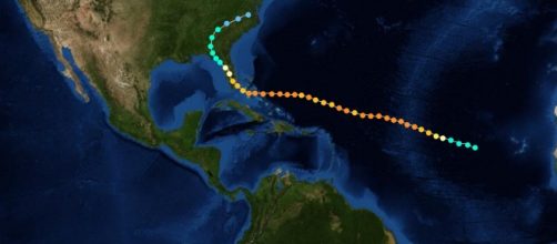
These days everyone has access via the internet to knowledge. Advances in technological science also applies to meteorologists and what they do. Nevertheless, predicting weather patterns is far from accurate most times. Examples include the infamous 1995 Hurricane Opal which changed from a category 1 to a category 4 hurricane overnight, leaving people to wake up only to run for safety on higher ground.
Back in 2011, Tropical Storm Harvey was the final tropical storm of the year, in a string of eight consecutive tropical storms which all died down and failed to reach Hurricane level.
Now, this doesn't mean that this will be just like last time as any betting girl will tell you, just because you won doesn't mean it's safe to place the same bet twice. Evacuations are therefore being advised and although people aren't responding like they should with some even holding hurricane parties, there are still some who are taking this seriously.
Back in 1935, on September 2nd, Labor Day, there was a category 5 event that made landfall along the Florida Keys and the people in the Keys were hit with 200 mph wind gusts, a storm surge of fifteen feet, and waves that carried everything before them. This earned it the name 'Storm of the Century.' Most would admit that this is an experience that is far from something most people could wish upon their worst enemy.
Hurricane threat level classification
Now for all those wondering what all these category 1 to 5 really mean, well here's a little history on this. The method was first discovered in the late 1960's by Herbert Saffir who was a structural engineer and wanted to gauge the potential of destructive hurricanes. Later in the 1970s, it was expanded by Robert Simpson who was then the Director of the National Hurricane Center.
Category one consists of these wind speeds; 33–42 m/s, 64–82 knots74–95 mph, 119–153 km/h. This is followed by category two which has these wind speeds; 43–49 m/s, 83–95 knots96–110 mph, 154–177 km/h. The next level, a category three, has these wind speeds; 50–58 m/s, 96–112 knots111–129 mph, 178–208 km/h.
Second highest on the scale is a category four with these wind speeds; 58–70 m/s, 113–136 knots130–156 mph, 209–251 km/h. The highest and most destructive is a category five which has the following wind speeds; ≥70 m/s,≥13 knots ≥157 mph, ≥252 km/h
The potential damage starts from category one, and you can expect very dangerous winds that will produce some damage, up to the highest level category five which leaves catastrophic damage in its wake. There are a couple of winds which have passed a category 5 speeds but these are few as winds above category five are already catastrophic to structures, so there is no need to add another level.
Residents prepare for evacuation and load sandbags in preparation for Harvey
Following advice to evacuate, there are residents filling sand bags so as to secure their investments from the rainfall expected throughout the weekend starting from today. Some are moving to areas where the storm is not expected to hit.
Rice farmers in coastal Matagorda County are harvesting their rice in anticipation for the storm as Exxon Mobil Corp and Royal Dutch Shell PLC are shutting down production and evacuating their employees from potential danger zones.
Along the coastline, seas could rise 5 to 7 feet ( 1.5 to 2.1 meters) above ground level and from 10 to 15 inches (25 to 38 centimetres) of rain will probably fall across parts of Texas, the Hurricane Centre said.
Some areas could get as much as 25 inches of rain. The Hurricane is also expected to slow down once it reaches the mainland which means that there will be a prolonged period of rain in the area which is more than likely to cause flooding.
I will keep you abreast of situations as they change. Any suggestions or opinions please leave them in the comment section below.


