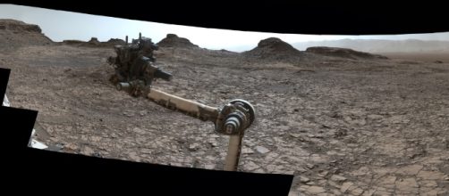
on one of the latest 360-degree color images from NASA´s Mars rover, the land features of lower Mount Sharp were captured. The rover took a full view of the site known as Matt Buttes at the very start of the slope that characterize the land feature know as Mount Sharp. The rover used its MastCamera on August 5, 2016-four years after having landed on Mars, to capture a few dozen images of the interesting scenery in the vicinity of Gale Crater-the land feature, where curiosity if performing Martian studies.
Murray Buttes
this feature ion Mars is a mesa within the Murray Buttes area, characterize by a fracture pattern protruding from the eroded rock.
the mesa represents a leftover of crater floor sediments. lying over sedimentary rock formations. It´s planned that curiosity explore this sedimentary formation. this feature is covered with rock that prevents the erosion of the mesa.
curiosity´s mission
Early in its mission, curiosity was able to explore and examine an ancient habitable environment, which is what the plan was intended for. On an extended mission, the rover will be climbing the mountain known as Mount Sharp gradually as it travels up the mountain to study its younger layers. The main objective is to get a deeper understanding of the water conditions that could have existed in the past and would have been favorable for the evolution of microbes.
This could uncover the evolution of the planet as it underwent environment transformations from habitable conditions into more inhabitable ones.
scientific findings
the discoveries about the past environmental conditions on Mars have been considered as high priority planetary science objectives, as they will help prepare the grounds for the first mission to Mars in a manned vehicle which is planned to be launched in 2030 and help advance into Mars´exploration.
The wide angle vie won the surroundings of lower Mount Sharp was taken with curiosity´s MastCam. NASA´s curiosity rover is close to begin its ascendance through the hills of this Gale Crater features, disclosing more interesting features of the layered terrain.

